Ordnance Survey Bench Marks
Overview
Bench marks are the visible remains of height measurements made by the Ordnance Survey. When used in conjunction with older Ordnance Survey maps they indicate the height above sea level at the point of the bench mark. The maps show a bench mark symbol, the letters BM (or B.M.) and the measured height above sea level. Since 1921 all heights are measured relative to a calculated average sea level at Newlyn in Cornwall. Before 192, Liverpool was used, but there were two different datum points.
Types of Bench Marks
There are a small number of standard designs for these:
- Fundamental Bench Marks (FBM)
- Flush Bracket Bench Marks (FL BR)
- Projecting Bracket Bench Marks
- OSBM Bolts
- Cut Marks
- 1GL Bolt
- Rivet or Pivot
The network of bench marks has had little maintenance since the early 1980s when satellite technology took over. Many bench marks have been destroyed by to building work, demolition, and the widening of roads.
Ordnance Datum (Great Britain)
To talk consistently about the height of something (or its altitude) we need to establish a point of reference. The most common point of reference you will come across is “above sea level”. But what does “above sea level” mean as the level of the sea goes up and down with the tides?
Between 1915 and 1921 accurate measurements of tide heights were made at the end of Newlyn pier in Cornwall. From these measurements an average, or mean, tide height was calculated, and this is “sea level”. All heights are measured relative to the mean tide level at Newlyn. Before this, other data were in use. The 1840 levelling was carried out using a datum at St John’s Church in Liverpool (now demolished). From 1844 this was changed, and the datum was a tidal pole at Victoria Dock in Liverpool. There were other measuring points, but Liverpool and Newlyn are the main two as far as Great Britain is concerned.
Newlyn and Liverpool only cover Great Britain. Alternative data were established for islands and regions.
Today, when we say “above sea level” what we are saying is above the calculated mean tide level, or Ordnance Datum, at Newlyn. This is abbreviated to ODN – Ordnance Datum Newlyn.
When an Ordnance Survey map shows you that the summit of Mount Snowdon is 1,085 metres, that height is relative to ODN.
Levelling
The height of all the bench marks was established in a process called levelling and measures the heigh relative to an Ordnance Datum. There were three major levelling exercises carried out for England. The first took place between 1840 and 1860. The second levelling was carried out between 1912 and 1921 and the third levelling was carried out between 1951 and 1956. The second and third levelling process were relative to ODN.
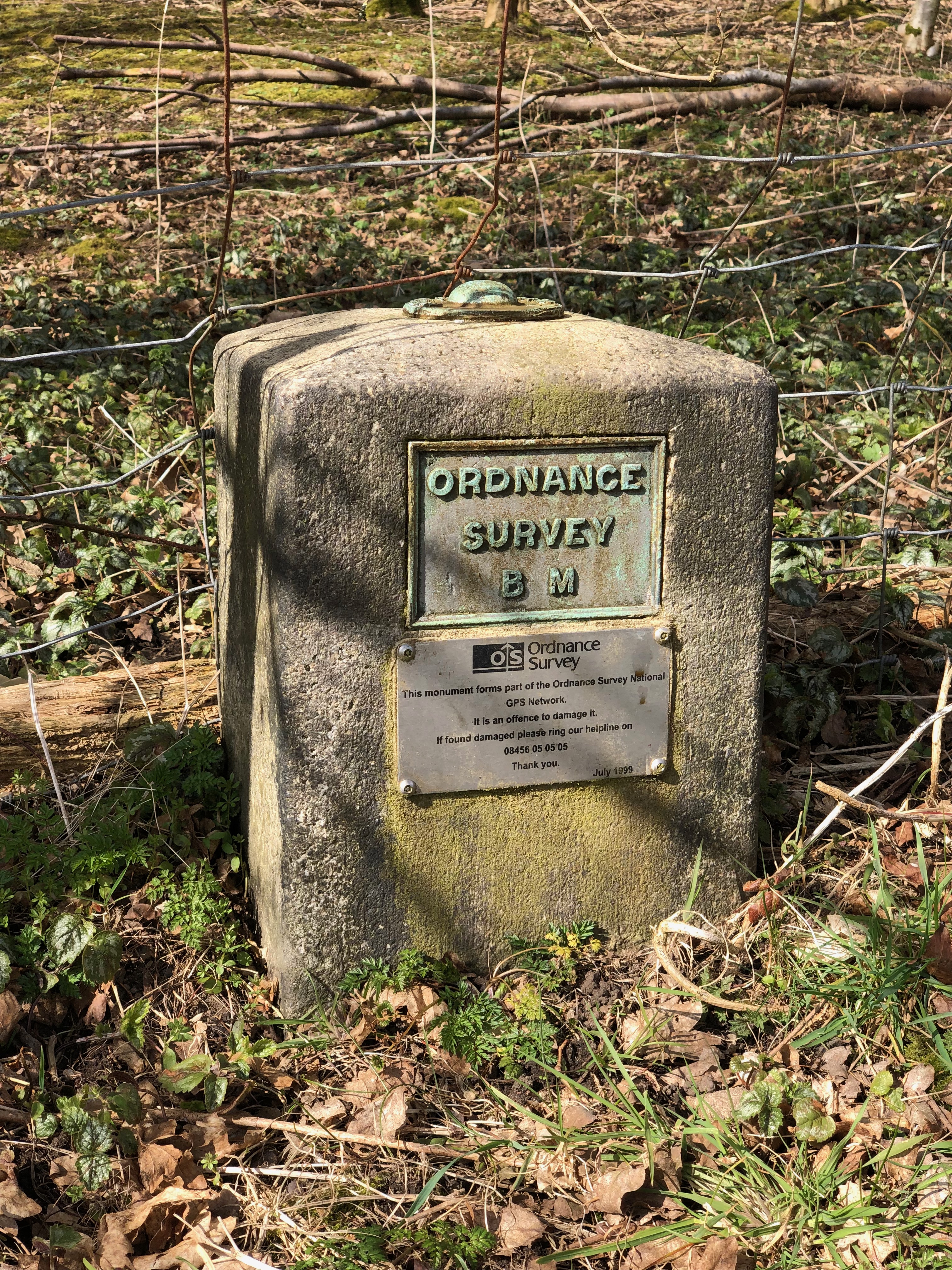
Fundamental bench marks
Unlike other types of bench marks, the fundamental bench mark (FBM) is still in use and they are maintained by the Ordnance Survey. There are 180 FBMs and they provide the basic levelling framework across the country. They are located about 40 km apart along lines of levelling. There is a brass bolt at the top of a small concrete pillar which is used for everyday purposes. For more accurate measurement there are two further reference points: a gunmetal bolt and a flint in a burried chamber.
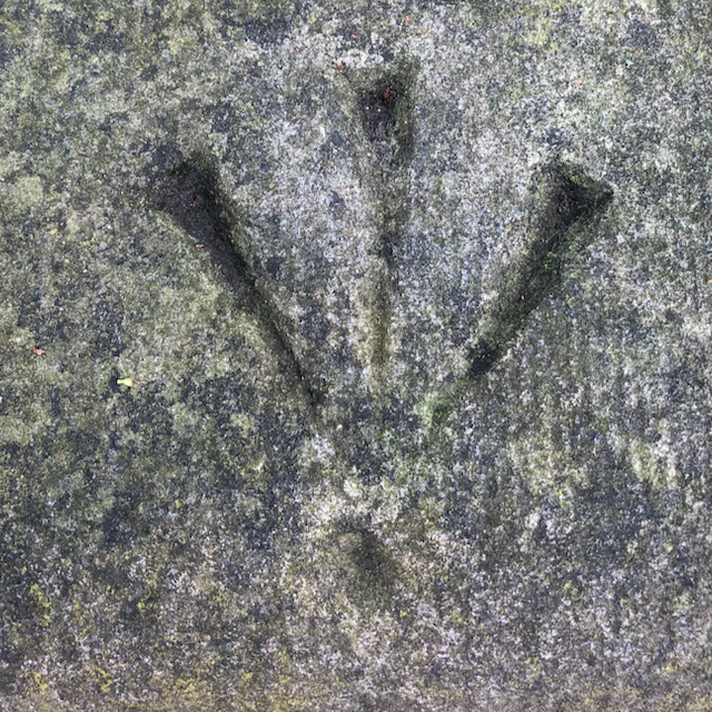
Flush Brackets
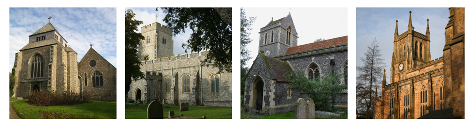
After the FBM the next type of bench mark is the flush bracket (FL BR). These are common on Ordnance Survey trig points, bridges, and church buildings. It is a metal plate about 9cm wide and 17.5cm tall. They are spaced about 1½km apart along levelling lines and at important junctions of secondary levelling lines. Each bracket carries a unique reference number. The height is measured at the top of the arrow on the face via a small metal platform that attaches using the two slots at the top.
Projecting Brackets
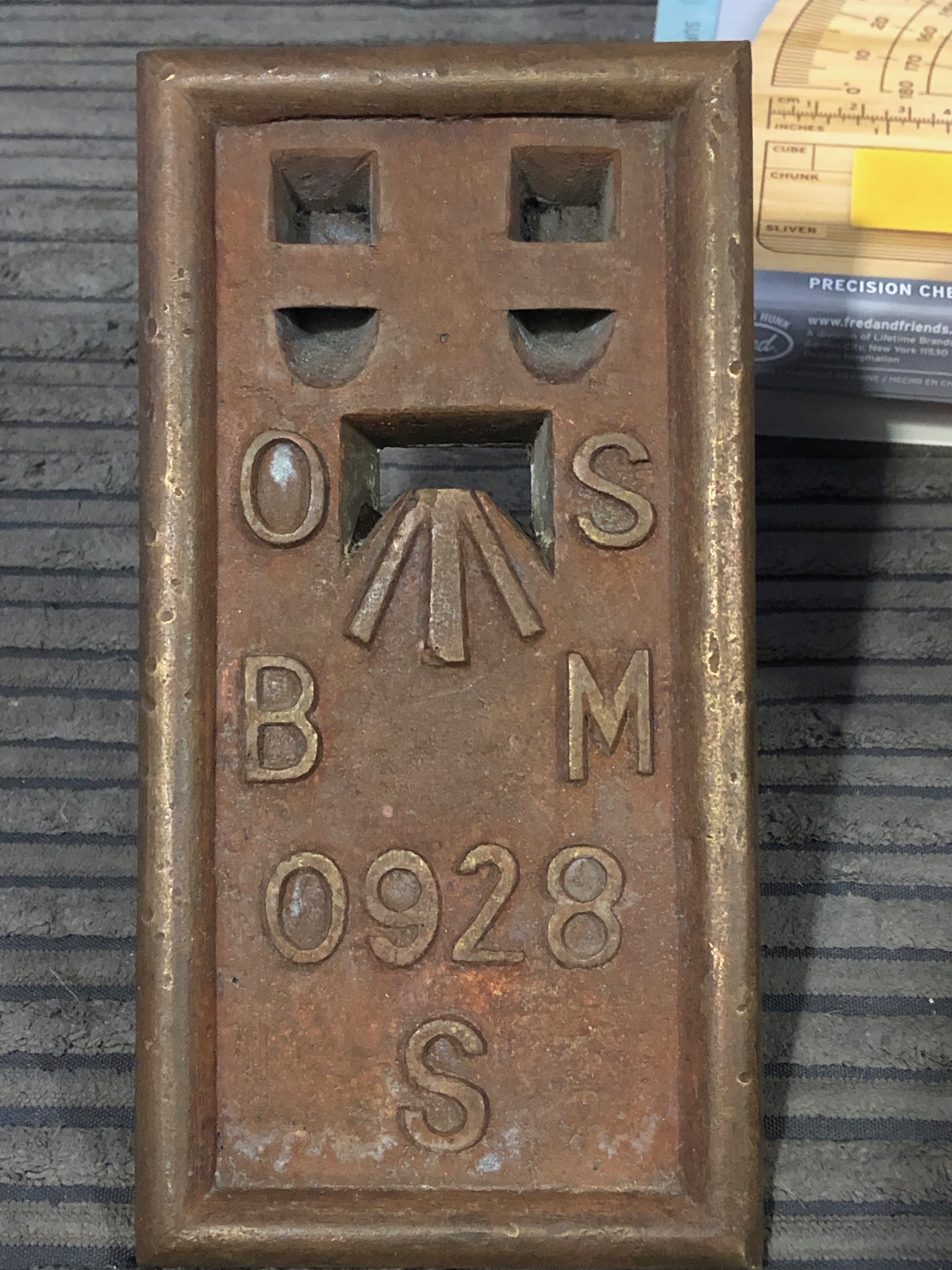
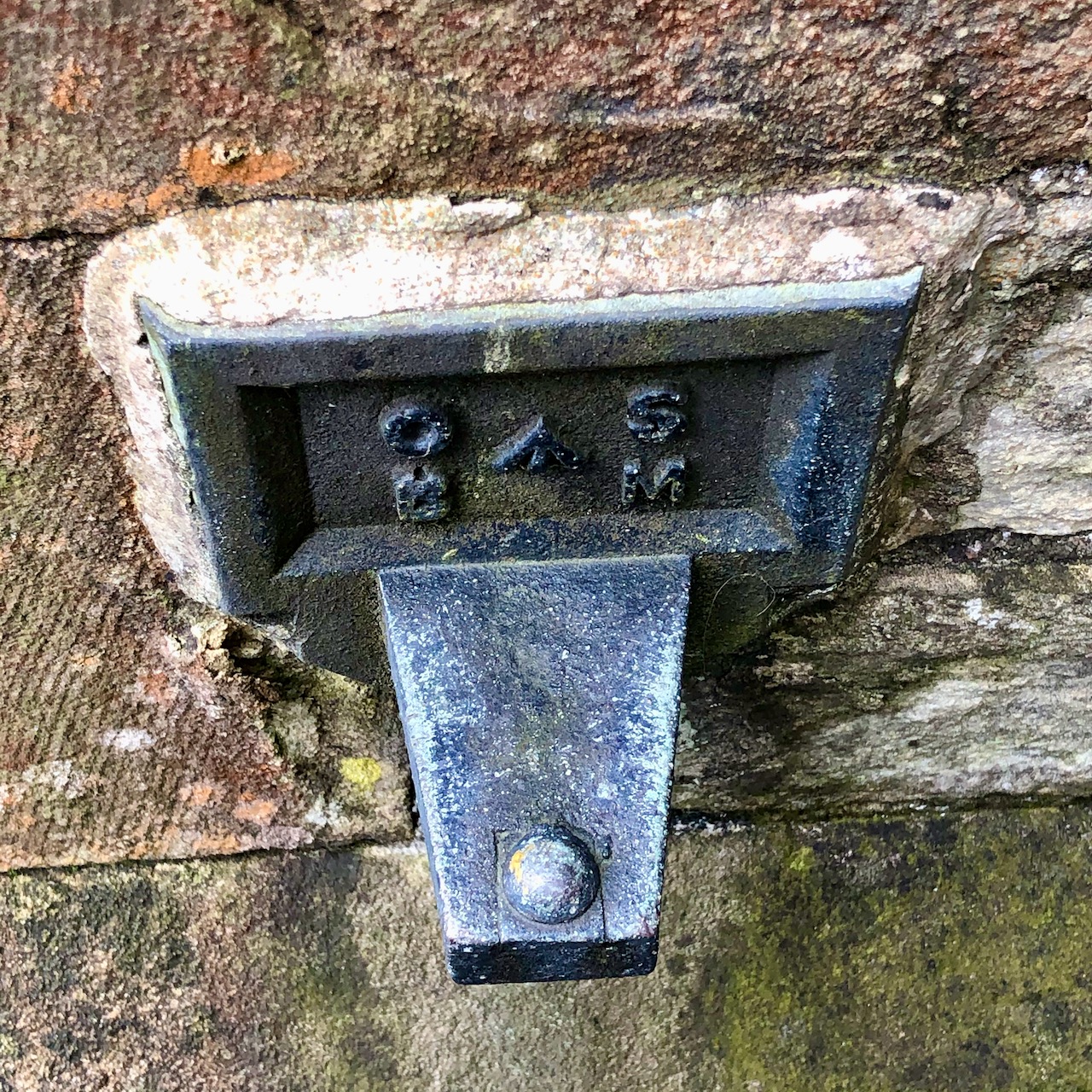
These are not common. Like a flush bracket, they are mounted on vertical surfaces and consist of a small metal plate with the letters O S B M and a small arrow cast into it. A bracket projects from the base of the metal plate. There are about 260 of these known to have been used and as far as I can tell only 33 have survived.
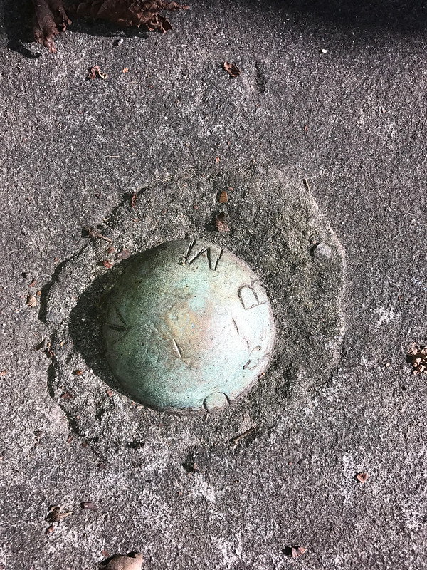
OSBM Bolts
Bolt bench marks are mushroom-headed brass bolts engraved with the letters ‘OSBM’ and an arrow. They are normally found in horizontal surfaces like steps, foundations or concrete blocks. The bolt has a 60mm diameter.
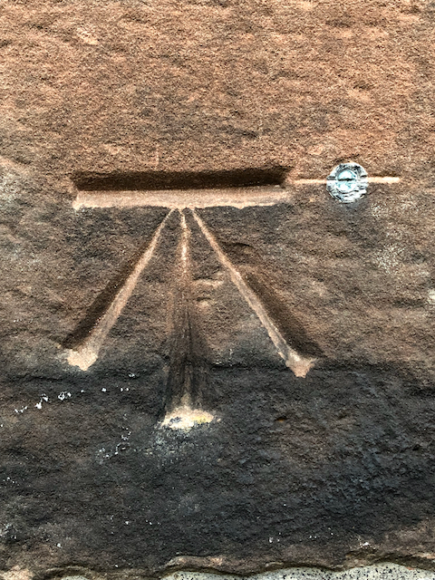
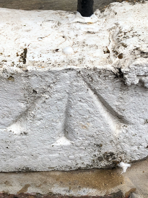
Cut marks
The cut mark is ubiquitous and can be found on houses, walls, stones, churches … even boulders. They consist of a cut bar with an arrow below. The height is measured at the horizontal bar and they are always on vertical surfaces. You will sometimes come across an inverted cut mark; this normally indicates that the cut mark has been cancelled and shows that it may have been relocated.

Public Abstract (1 GL) Bolt bench mark
The bolt bench mark looks like a cut mark and appear on vertical surfaces. The cut mark is accompanied by a small metal bolt. The bolt can be incorporated into the bar or to one side. PA Bolts tend to be placed before 1921 so are frequently measured relative to other datum points (i.e. Liverpool).
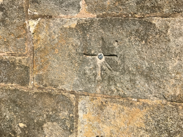
Rivet or Pivot
Rivet and Pivot bench marks are like each other. Found on horizontal surfaces, although the arrow mark is sometimes on a vertical surface, they comprise a cut mark and either a brass bolt (or rivet) or, in the case of a pivot, a small hollow. A pivot is often used when the surface is soft and could be broken or damaged by the insertion of a rivet. The hollow, or depression, would be used to hold a small steel ballbearing, ⅝ of an inch, and the measuring staff placed on the ballbearing. [My thanks to John Talbot for the information on pivots.]
Location and Descriptions
The Ordnance Survey provides three pieces of information that describes the location of a bench mark: grid reference; height above the ground; and a detailed description of its position.
Grid Reference
The grid reference is given as two letters followed by a four-figure easting and a four-figure northing. An example being SD 6831 2798. This format of grid reference gives the lower left corner of a 10 x 10 meter square. The bench mark will, or should, be in that square. Worst case is that the bench could could be just over 14 meters from the given grid reference.
- The two letters, SD in this case, identify the 100 km × 100 km grid square.
- The first four digits, 6831, give the easting (distance east/right) and is accurate to 10 meters
- The second four digits, 2798, give the northing (distance north/up) and is also accurate to 10 meters
Height Above The Ground
The height above the ground, or Above Ground Level (AGL) helps place the bench mark vertically. Note that rivets and pivots are often shown as 0.0 meters above the ground which usually refers to the horizontal surface they are on.
It is worth noting that the ground level can have changed over time as pavements, for example, are built or changed.
Description
The grid reference and above ground level provide an accurate three dimensional position for the bench mark.
The Ordnance Survey provide a ‘description’ which describes the position for the bench mark. The description uses a significant number of standard abbreviations which, initially, can be difficult to understand. A list of those abbreviations is available on the Bench Mark Database site in the Help -> Abbreviations page.
Example – St Andrew’s Church
“CUT MARK: ST ANDREWS CH 6.4M NW ANG N FACE (ODN 5.112m, AGL 0.2m).”
The bench mark is a cut mark. It is on St Andrew’s Church. It is positioned 0.2 meters above ground level, 6.4 meters from the north-west angle on the north face of the Church. The datum is 5.112 meters above Ordnance Datum Newlyn.
Example – The Royal Opera House
“CUT MARK: N ANG ROYAL OPERA HOUSE JUNC FLORAL ST BOW ST (ODN 23.631m, AGL 0.6m).”
The bench mark is a cut mark. It is 0.6 meters above ground level at the north angle of the Royal Opera House at the junction of Floral Street and Bow Street. The datum is 23.631 meters above Ordnance Datum Newlyn.
Bench Marks I have Found
You can see a list of the bench marks I have found here on the bench-marks.org.uk site.
You can also see the bench marks I have found shown on a map. I last updated this on 8 September 2025.
Bench Marks That I Didn’t Find
Sometimes, no matter how hard you look a bench mark can’t be found. It could have been destroyed – demolition, building work, road widening – or it is there and I just didn’t find it.
Where Can You Find Bench Marks
The Ordnance Survey still has a database listing the grid reference and a description of bench marks. You can access it from their web site.
Ordnance Survey Bench Mark Locator
There is a very active Facebook group discussing and sharing photographs of UK bench marks. People there are very helpful and always willing to share their knowledge.
The Bench Mark Database is used by many bench mark hunters to both log their finds and to plan days out hunting. This site contains lots of useful information and advice. The Bench Mark Database is also useful as a quick and simple way of finding previously found bench marks using: grid reference, latitude and longitude or simply a post code. You can simply enter a grid reference, latitude and longitude or post code into the search box, top right, and hit the search button. A list of the nearest known bench marks will be displayed. Click on an individual bench mark to see the details.